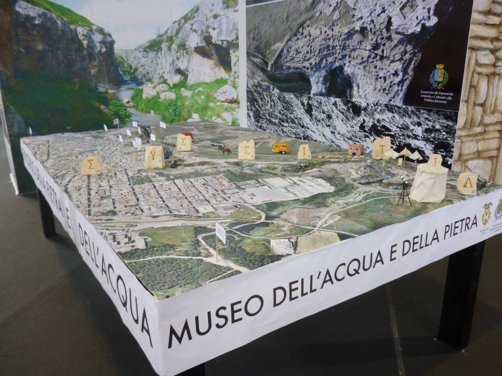
The project for the realization of nature trails in the Gravina Gravina area in Puglia is part of the Museum of Water and Stone, a museum of the territory that has Gravina di Gravina and its historical, cultural and environmental values as its focal point. This is a high quality area subjected to archaeological and landscape constraints that require interventions based on maximum respect and no invasiveness. The itineraries are aimed at allowing naturalistic appreciation through the direct experience of space and places in a new approach based not on setting up areas with pre-packaged presentations and interpretations but on sensory stimulation, the invitation to curiosity and research. The design takes into account environmental issues, ecosystem management, historical values, aesthetic qualities and anthropological narratives.
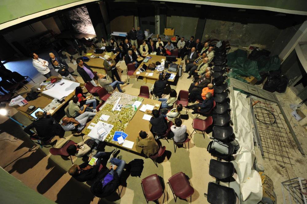
The design methodology stems from two fundamental aspects: integration and participation. The design is integrated, able to consider different value options, which involve impacts on diversified sectors, on extended and long-term dimensions and therefore requires a multidisciplinary approach; and it is participatory, ie it involves the subjects with local knowledge, the determinants in the decision-making options, the operators and economic actors whose active involvement in the assessments and choices becomes a determining element of the project and contributes to its feasibility. The design process was carried out in a participatory way through the creation of Syssitia, social design laboratories. The syssitia were the custom, reported by Aristotle, of the public banquets typical of the ancient southern peoples where common decisions were made. The historical quote recalls that the success of great civilizations of the past was obtained thanks to institutions that allowed participation, inclusion and identity. The Municipality of Gravina wanted to recall this ancient custom by re-proposing itself as a city that makes its element of historical heritage, memory, hospitality and conviviality. Furthermore, participation is an added value to the whole process since the involvement of local knowledge subjects, of those who have decision-making roles, of operators, favoring the active presence of citizenship in the choices and in the realization, is a guarantee of operations and failed.
The Ecomuseum creates an innovative museum proposal that enhances and enhances the environmental and historical aspects of Gravina through itineraries, visualizations, narrative explanations capable of blending nature, culture and sociality. The Ecomuseum is in fact a museum of the territory where the exhibitions of objects do not count but the direct experience of space and places lived through the itinerary and the journey and through the intense relationship with the community. Conviviality, the way of living, living and feeling the landscape is therefore an integral part of the realization of an ecomuseum. Gravina in Puglia is one of the cities in the world that expresses this potential in the most intense way. It is in name and in fact the city of the Gravines par excellence. It is the extraordinary proof of how the places of the Gravine, with spectacular characters, but certainly not of easy conditions, have been transformed over time by blending nature and culture. The water was captured, collected, transported, and the stone was excavated, transported, assembled and processed. The first is the fundamental element for life the second has constituted its shelter. Water and stone, protagonists of this story together with the community that staged it, blend together along the abyss of Gravina where, on one side, the prehistoric and ancient past with the Botromagno hill, and on the other the one historical and contemporary, with the current urban landscape. The whole is a theater of the world and of civilization, a tale of human events visible in graffiti, cavities, underground meanders, archeology, urban patterns. Here, traced by water and carved in stone, everything is still present: the works and the myth, the fatigue and the aspirations, the ingenuity and the symbols.
The task of the ecomuseum is to present, make accessible and invite to make a unique direct experience in this grandiose scenario.
The gravina of Gravina marks the project area with its trend from north to south. Its canyon, with its great naturalistic and environmental characteristics, separates and merges the components of the landscape system into a monumental design. To the west, on its right side, is the Botromagno hill with archaeological remains. To the east, on the left bank, the post-classical and medieval historical center. An extraordinary stratigraphy is determined that does not occur, as usually happens, superimposed, with the more recent periods built over the older ones, but juxtaposed in such a way that the subsequent realizations flank and do not conceal the archaeological pre-existences. The two banks so profoundly marked by geography and history are united by the splendid aqueduct bridge on tuff arches of the 18th century. The bridge is a point of passage and contact that separates the northern part of the riverbed from the southern part. An orthogonal axiality is determined, constituted by the North – South course of the ravine, intersected by the East – West path from the historic center to the archaeological area. Axiality that has its fulcrum in the aqueduct bridge and divides the places into specific sectors. Based on this geometry, the project defined the founding elements of the landscape of Gravina, consisting of Water, Stone, Time and Space. Around these themes the map of the prevailing environmental, historical, anthropological and landscape expressions that constitute the complex of the Museum of Water and Stone was built. The realization of the itineraries allows the balanced fusion and the fruition favoring the functioning and the regeneration of the system. In the North the Water sector is the area of the gravina where nature is most felt and here, along the course, naturalistic itineraries are held. To the south, beyond the bridge, the Stone sector constitutes that part where human intervention has more and more influenced and excavated natural geology, creating the wonders of underground architecture and rock settlements and creating extraordinary moments of nature-culture fusion such as hanging and terraced gardens. In the West the Tempo sector characterizes the archaeological area rich in testimonies that from the most remote prehistoric eras develops up to the mighty city of the Greek Magno period and to the achievements of the Roman era. To the East, the Space sector defines the historic city, from the intricate urban fabric structured by water ducts and hypogean labyrinths that has formed since late antiquity and is marked by monumental vestiges that follow one another from the medieval period until the eighteenth and nineteenth centuries.
The Water sector is where the project itineraries take place. The sector is bordered to the south by the aqueduct bridge, to the west, on the right bank of the ravine, by the road that crosses the archaeological area with a boundary that follows the road to the Lamascesciola railway station.
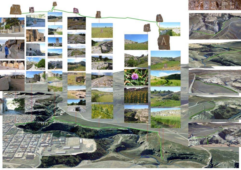
The visit itineraries have the task of making the places usable by inserting them in a spatial, sensorial and mental network of connections and meanings. Connection, usability and narration permeate the places of meaning and values, contributing to their protection, integration and urban development and transmission to future generations. The itineraries are composed of a main route of easy accessibility with secondary branches for more prepared users. The route starts from the City to cross the gravina on the aqueduct bridge and wind north to the point of the ravine where the riverbed widens into the flat prairie. A journey through time and myth takes place from the historic center to archeology and beyond this in a growing immersion in the landscape and nature. The theme is that of the water from which the course recovers, from the fountain, at the corner of Corso Garibaldi and Via Madonna della Stella, proceeding by accumulating knowledge and sensations, until the discovery of its origins. The path is divided into 8 parts as many as the letters of the word Syssitia, name of the symposia of the ancient local peoples, to which the social laboratory created for the social design of the museum was inspired.
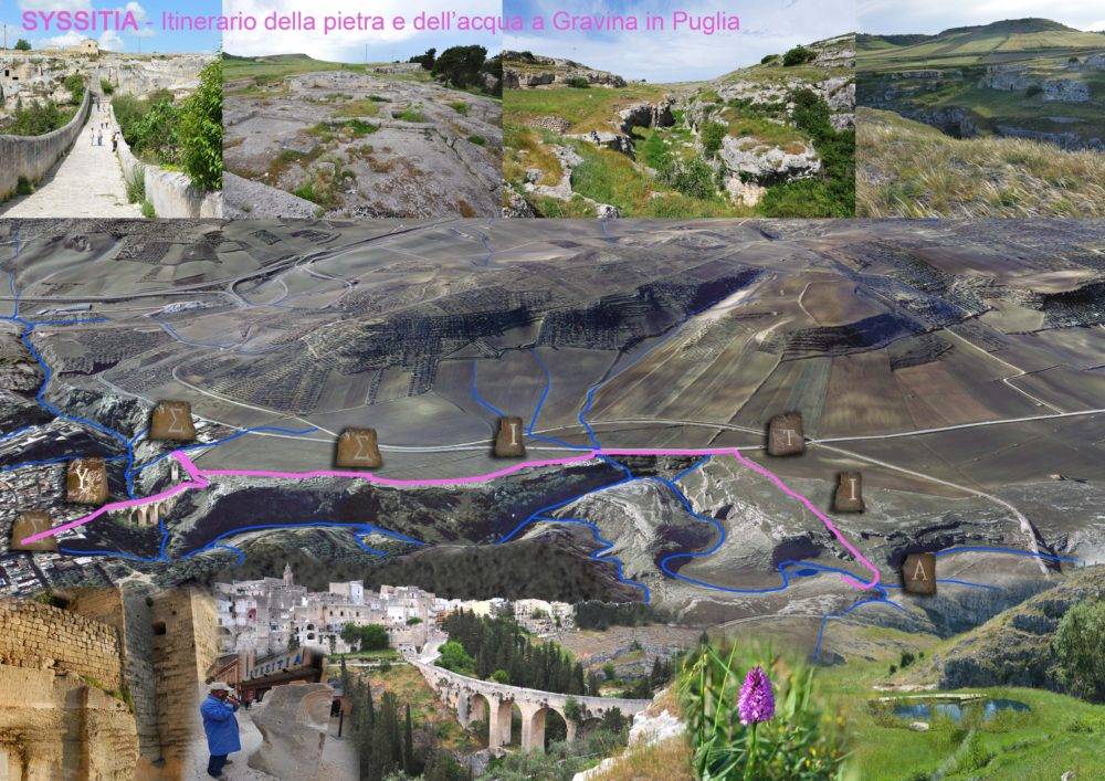
The letters, carved on stone boulders by artists of Gravina, are installed along the route to mark the itinerary. Each of these 8 parts constitutes a room of our museum that as a museum of the territory has a particular spatial dimension. A conventional museum, in fact, has objects displayed on two-dimensional walls whose composition becomes a three-dimensional architectural volume. The museum of the territory has as walls open, three-dimensional spaces that, through the tactile, sensory and spatial experience, reveal further unusual dimensions to the visitor. The result is a multidimensional space made of conceptual rooms, of knowledge and memory in which the tourist, starting from the elements of excellence of the territory, can get lost in a series of infinite connections. The museum is thus a hyper-architecture unraveled in the territory in the various rooms made of multisensory experiences that the visitor will be able to reconstruct in his own cognitive construction. There is therefore no compulsory reading of places with obligatory points of view and points of view and unambiguous interpretations, but indications and stimuli to entice research and elaboration. The letters carved in the stone boulders to mark the various rooms, stanzas or passages, symbolize this choice. The word to guess by reassembling it in the itinerary is the word Syssitia, hidden precisely because it is openly placed in front of everyone and engraved through stones in the landscape. With the letters you can write endless stories and the carved boulder becomes the initial of a series of keywords that can always be reworked. The first S is the word thirsty and the sculpture is a little fountain where it is possible to drink. But it is also a thirst for knowledge, S for Survival or Sensations and so on in continuous new narratives. Next is the I information, the S of Silence and the Sacred, the I of Incanto the T of time, the I of Identity up to the A of water, the origin of all living things. Here an area of sensory experience with water is organized, dedicated above all to children, based on the creation of a biostagno modeled according to the principles of blue architecture and landscape and fed with water from the gravina purified through the methods of naturalistic engineering. The area is served by an ecological composter toilet equipped with a solar panel for lighting, a dressing room and a first aid post.
The basic plot is communicated by equipping each sculpture with a qr code tagging system that allows the download of information on the personal smartphone and a progressive number that refers to the same interpretative cards downloadable from the internet or received at the information point for those who do not use the smartphone. The chosen method allows not to place panels on the path and to be able to constantly and constantly increase the information by modifying the contents on the internet. The creation of the website is required for a subsequent project because the expense is not compatible with this funding.
The choices of realization pursue the minimum invasiveness in all aspects of the project. The interventions along the routes are limited to the placement of the sculptures, the adaptation of the paths, the installation of cameras and the arrangement of the final area of the water. The itinerary is equipped with a nomad equipment, consisting of light equipment that will be assembled and disassembled according to the needs of refreshment, events and conferences based on a catering container block, gazebo, 60 m2 yurt, chairs, reproduction equipment multimedia and amplification. An off-road electric vehicle allows the transport of equipment and the necessary energy on site. The vehicle also has the function of a means of control, rescue of wheelchairs for the disabled and elderly. The main route has been specially tested to allow easy travel for anyone, even for the disabled and the elderly. The paths are adequate without the introduction of foreign materials, through, cleaning, consolidation with local stone, securing and protection with minimal interventions in wood. The routes are indicated with the international signaling system with simple stone painting. The cameras are installed on the existing light poles. From them and from the access road to the archaeological area it is possible to check the whole itinerary from above. The information point in the medieval stands is also the control center.
